Earthquake's Hidden Points: Focus & Epicenter Explained!

The United States Geological Survey (USGS) provides critical data for understanding seismic events, revealing essential details about fault lines. Scientists meticulously study seismic waves, an invaluable tool, to pinpoint locations deep beneath the Earth's surface. These locations provide insights into plate tectonics. The Richter scale is a tool for assessing the intensity of ground shaking during an earthquake. Accurate determination of these points enables a comprehensive analysis of seismic events. It is important to understand what is the focus and epicenter of an earthquake to assess hazards and mitigate risks. Seismologists play a key role in interpreting data, analyzing ground motion, and identifying the source and the initiation point of energy release during an earthquake, revealing what is the focus and epicenter of an earthquake.
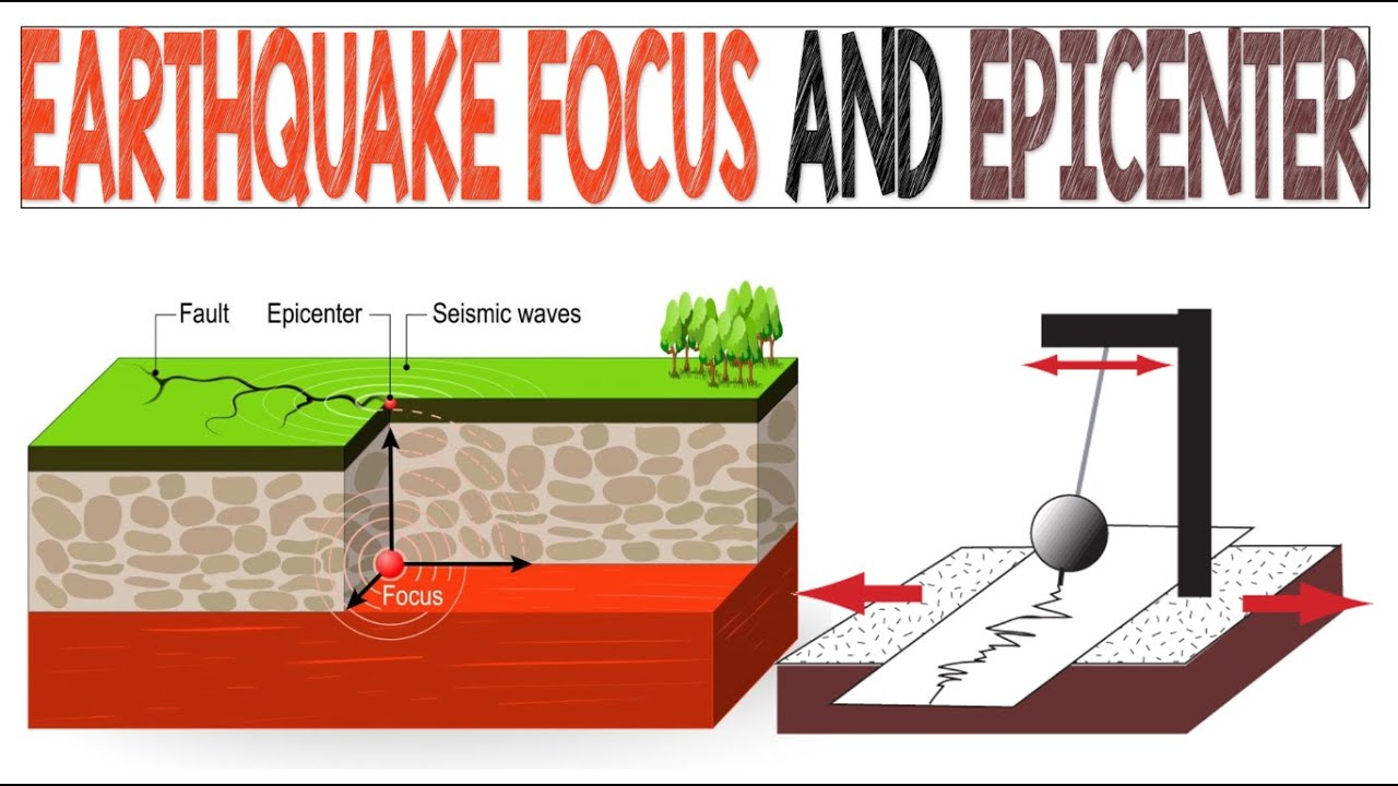
Image taken from the YouTube channel EarthPen , from the video titled Earthquake Focus and Epicenter | Animation .
Earthquakes, those sudden and often devastating tremors, are a stark reminder of the dynamic forces shaping our planet. These events, ranging from barely perceptible vibrations to catastrophic ground movements, can trigger landslides, tsunamis, and widespread infrastructure damage, profoundly impacting communities and economies. Understanding the fundamental aspects of earthquakes is crucial for mitigating their risks and fostering resilience.
At the heart of earthquake science lie two key concepts: the focus (or hypocenter) and the epicenter. These terms, while often used interchangeably in casual conversation, represent distinct yet interconnected aspects of an earthquake's origin and impact.
The Focus and Epicenter: Defining Earthquake Origins
The focus, also known as the hypocenter, marks the precise point within the Earth where the earthquake rupture initiates. This is the three-dimensional location where the built-up stress overcomes the friction, causing the rocks to fracture and release energy.
Conversely, the epicenter is the point on the Earth's surface that sits directly above the focus. It's the two-dimensional location most commonly cited in news reports and earthquake catalogs.
Understanding the relationship between these two points is fundamental to comprehending how seismic energy propagates and affects the surface.
Seismic Waves: The Messengers of Earthquakes
Earthquakes generate various types of seismic waves that radiate outward from the focus. These waves, acting as carriers of energy, travel through the Earth's interior and along its surface.
The primary types of seismic waves include:
- P-waves (Primary waves): These are compressional waves that can travel through both solids and liquids.
- S-waves (Secondary waves): These are shear waves that can only travel through solids.
- Surface waves: These waves, including Love and Rayleigh waves, travel along the Earth's surface and are often responsible for the most significant ground shaking and damage.
Purpose of This Article
This article aims to provide a clear and concise explanation of the focus and epicenter, emphasizing their distinct definitions and their crucial relationship in understanding earthquake phenomena. By differentiating between these two fundamental concepts, we hope to provide you with a more solid understanding of earthquake science.
Seismic Waves: The Messengers of Earthquakes
Earthquakes generate various types of seismic waves that radiate outward from the focus.
These waves, acting as carriers of energy, travel through the Earth's interior and along its surface.
With this in mind, our attention now turns to the precise where of an earthquake's genesis: the focus, or hypocenter.
The Focus (Hypocenter): Earthquake's Point of Origin
The focus, sometimes referred to as the hypocenter, is the heart of an earthquake.
It is the precise spot deep within the Earth where the rupture commences.
This is where the accumulated tectonic stress finally overcomes the frictional forces, causing the rock to fracture and release tremendous energy in the form of seismic waves.
Defining the Hypocenter
Imagine the Earth as a giant puzzle of tectonic plates, constantly pushing and grinding against each other.
Over time, this movement generates immense stress along fault lines.
The focus represents the precise three-dimensional location, defined by depth, latitude, and longitude, where this built-up stress is abruptly released.
It's the underground epicenter of the seismic event.
This location marks the origination point of the earthquake's energy.
The Significance of Depth
The depth of the focus plays a crucial role in determining the intensity and impact of an earthquake on the surface.
Shallower earthquakes, those occurring closer to the Earth's surface, tend to be more destructive due to the shorter distance the seismic waves have to travel.
This means the energy is more concentrated when it reaches populated areas.
Conversely, deeper earthquakes, while releasing the same amount of energy, often cause less surface damage because the seismic waves dissipate as they travel through the Earth's mantle.
Classifying Earthquakes by Depth
Earthquakes are generally classified into three categories based on their focal depth:
-
Shallow-focus earthquakes: These occur at depths of less than 70 kilometers (43 miles) and are the most common type. They often cause the most significant damage.
-
Intermediate-focus earthquakes: These occur at depths between 70 and 300 kilometers (43 and 186 miles).
-
Deep-focus earthquakes: These occur at depths greater than 300 kilometers (186 miles). The mechanisms that cause deep-focus earthquakes are still not fully understood, adding to the mystery surrounding these powerful events. These earthquakes may be felt over a wide area, but surface damage is generally less severe compared to shallow events.
Understanding the depth of an earthquake's focus is therefore paramount in assessing potential hazards and developing effective mitigation strategies.
Conversely, deeper earthquakes, while often felt over a wider area, tend to be less destructive at the surface because their energy is dissipated as the seismic waves travel through a greater distance of the Earth’s interior. This understanding of the focus provides essential context as we now turn our attention to the epicenter, the point on the surface most directly impacted by this subterranean activity.
The Epicenter: Directly Above the Earthquake's Core
The epicenter is the point on the Earth's surface that sits directly above the focus (hypocenter) of an earthquake.
It's the geographical location one would pinpoint on a map to represent where an earthquake is centered.
While not the earthquake's origin, understanding the epicenter is critical for rapid assessment and response efforts.
The Surface Projection of Seismic Activity
The epicenter can be visualized as the vertical projection of the earthquake's source onto the Earth's surface.
Imagine shining a beam of light directly upwards from the focus. The point where that beam hits the surface is the epicenter.
This point is defined by its geographical coordinates.
The Center of Initial Impact
Often, but not always, the strongest shaking during an earthquake is initially felt nearest to the epicenter.
The energy released from the focus radiates outwards in all directions.
The location on the surface that is directly above the focus is often the first to experience significant ground motion.
Latitude and Longitude: Pinpointing the Epicenter
Unlike the focus, which is a three-dimensional location (latitude, longitude, and depth), the epicenter is a two-dimensional location.
It is defined solely by its latitude and longitude coordinates, specifying its position on the Earth's surface.
These coordinates are essential for mapping and analyzing seismic events.
They allow seismologists to accurately track and study earthquake patterns across the globe.
Intensity Variation and Geological Factors
While the area around the epicenter often experiences the most severe damage, it's crucial to recognize that the intensity of shaking can vary considerably.
This variation depends on several factors.
Geological factors play a significant role.
The type of soil and underlying rock can amplify or dampen seismic waves.
Also, the distance from the epicenter is another vital factor.
Even though the epicenter might mark the initial point of impact, the distribution of damage can be complex and influenced by local geological conditions.
Conversely, deeper earthquakes, while often felt over a wider area, tend to be less destructive at the surface because their energy is dissipated as the seismic waves travel through a greater distance of the Earth’s interior. This understanding of the focus provides essential context as we now turn our attention to the epicenter, the point on the surface most directly impacted by this subterranean activity.
Focus vs. Epicenter: Untangling the Core Concepts
The focus, or hypocenter, and the epicenter are two fundamental terms in seismology, often used interchangeably but representing distinct aspects of an earthquake.
Understanding their differences and their intrinsic relationship is crucial for comprehending the dynamics of seismic events.
Distinguishing the Focus and Epicenter
The most fundamental difference lies in their dimensionality and location.
The focus is the three-dimensional point within the Earth where the earthquake rupture initiates. It has a specific depth, latitude, and longitude. It’s the true origin of the seismic event.
Conversely, the epicenter is a two-dimensional location.
It's the point on the Earth's surface that lies directly above the focus.
Think of it as the surface projection of the earthquake's source.
Focus: The Earthquake's Point of Origin
As the point of origin, the focus is where the rock fractures and the stored energy is released in the form of seismic waves.
The depth of the focus significantly influences the characteristics of the earthquake.
Shallow-focus earthquakes (less than 70 km deep) tend to be more destructive due to their proximity to the surface.
Epicenter: The Surface Manifestation
While not the earthquake's "source," the epicenter is a critical reference point for emergency response and public awareness.
It is the location most often reported in news bulletins and earthquake alerts.
The region surrounding the epicenter typically experiences the strongest initial shaking, although local geological conditions can modify this pattern.
The Inseparable Connection
Despite their distinct characteristics, the focus and epicenter are inextricably linked.
The epicenter is always located directly above the focus.
This vertical relationship means that knowing the location of one can help approximate the location of the other, particularly when depth information is also available.
Visualizing the Relationship
Imagine a straight line extending from the focus, deep within the Earth, perpendicularly upwards to the surface.
The point where that line intersects the Earth's surface is the epicenter.
A simple diagram illustrating this spatial relationship is essential for a clear understanding.
It provides a quick visual reference that reinforces the concepts of depth and surface projection.
The diagram should clearly show the focus as a point within the Earth.
It should also show the epicenter as a point on the surface directly above it.
Arrows can be used to represent the seismic waves radiating outwards from the focus.
This visual aid can be invaluable for educational purposes and for communicating earthquake information to the general public.
Conversely, understanding the location of both the focus and epicenter would be impossible without comprehending how the energy of an earthquake radiates outward. These energy releases travel in the form of seismic waves, each with its own unique properties and behavior. These waves not only allow us to pinpoint the origin of an earthquake but also give crucial insights into the Earth's internal structure.
Seismic Waves: Carriers of Earthquake Energy
When an earthquake occurs, the sudden release of energy at the focus generates vibrations that propagate through the Earth in the form of seismic waves. These waves are the messengers, carrying information about the earthquake's magnitude, location, and the properties of the materials they travel through. Studying seismic waves is critical for understanding not only earthquakes but also the Earth's deep interior.
Types of Seismic Waves
Seismic waves are broadly classified into two categories: body waves and surface waves. Body waves travel through the Earth's interior, while surface waves travel along the Earth's surface. Each type of wave has distinct characteristics that determine its speed, direction, and interaction with different materials.
Body Waves: Probing the Earth's Interior
Body waves consist of two primary types: P-waves and S-waves.
P-waves (Primary Waves)
P-waves, or primary waves, are the fastest seismic waves and are the first to arrive at a seismograph station after an earthquake. They are compressional waves, meaning that the particles of the material they travel through move parallel to the direction of wave propagation. This allows P-waves to travel through solids, liquids, and gases. P-wave velocity is affected by the density and elasticity of the medium, and the contrast in velocities allows inferences to be made about the composition of the layers they transverse.
S-waves (Secondary Waves)
S-waves, or secondary waves, are slower than P-waves and arrive later at seismograph stations. They are shear waves, meaning that the particles of the material they travel through move perpendicular to the direction of wave propagation. S-waves can only travel through solids because liquids and gases cannot support shear stresses. The absence of S-waves in the Earth's outer core provides strong evidence that this layer is liquid.
Surface Waves: The Destructive Shakers
Surface waves travel along the Earth's surface and are responsible for most of the damage associated with earthquakes. They are lower frequency than body waves, and are of larger amplitude. There are two main types of surface waves: Love waves and Rayleigh waves.
Love Waves
Love waves are horizontal shear waves that travel along the Earth's surface. Their motion is perpendicular to the direction of propagation, and they do not exist in liquids or gases. Love waves are typically faster than Rayleigh waves and can cause significant ground shaking.
Rayleigh Waves
Rayleigh waves are a combination of vertical and horizontal motion, resulting in a rolling, elliptical motion similar to that of waves on water. They are slower than Love waves and are responsible for much of the vertical ground motion felt during an earthquake.
Seismographs: Recording the Earth's Vibrations
Seismographs are instruments used to detect and record seismic waves. These instruments consist of a sensor that detects ground motion and a recording system that captures the data. Modern seismographs are highly sensitive and can detect even the smallest seismic waves from earthquakes occurring anywhere in the world.
The data recorded by seismographs, called seismograms, provide valuable information about the timing, amplitude, and frequency of seismic waves. By analyzing seismograms from multiple seismograph stations, seismologists can determine the location, depth, and magnitude of an earthquake. The arrival times of P-waves and S-waves, in particular, are used to calculate the distance to the earthquake's focus.
Conversely, understanding the location of both the focus and epicenter would be impossible without comprehending how the energy of an earthquake radiates outward. These energy releases travel in the form of seismic waves, each with its own unique properties and behavior. These waves not only allow us to pinpoint the origin of an earthquake but also give crucial insights into the Earth's internal structure.
Locating the Focus and Epicenter: The Role of Seismology
The science of seismology plays a critical role in understanding earthquakes, particularly in determining the precise location of both the focus and the epicenter. Seismologists utilize data collected from a network of seismograph stations around the world to achieve this. These stations act as sentinels, constantly monitoring ground movements and recording the arrival of seismic waves.
The Power of Seismograph Networks
Seismograph stations are strategically positioned across the globe to capture the intricate details of seismic waves generated by earthquakes. Each station is equipped with sensitive instruments called seismometers, which detect and record ground motion. The data from these stations, combined with sophisticated analytical techniques, allow seismologists to reconstruct the earthquake's source parameters.
Triangulation: Pinpointing the Earthquake's Location
Triangulation is the primary method used to determine the location of an earthquake's epicenter. This technique relies on measuring the arrival times of seismic waves – specifically P-waves and S-waves – at a minimum of three seismograph stations.
By analyzing the time difference between the arrival of P-waves and S-waves, seismologists can calculate the distance from each station to the earthquake's source. This is because P-waves travel faster than S-waves.
The greater the time difference, the farther away the station is from the earthquake. Once the distances from at least three stations are known, circles are drawn on a map with each station at the center and the calculated distance as the radius.
The point where these circles intersect represents the earthquake's epicenter. In reality, the circles might not intersect perfectly due to various factors, such as variations in the Earth's subsurface structure. Seismologists use computational methods to refine the epicenter location and estimate the uncertainty associated with it.
Determining the Focus Depth
Locating the focus, or hypocenter, requires additional analysis. The depth of the focus is determined using more complex techniques involving the arrival times and amplitudes of various seismic phases, as well as modeling the Earth's velocity structure.
The depth of the focus is a crucial parameter, as it significantly influences the severity of shaking at the surface. Shallow-focus earthquakes tend to cause more damage than deep-focus earthquakes, because the energy has less distance to dissipate.
The Role of the USGS and Other Organizations
Organizations like the United States Geological Survey (USGS), along with numerous international seismological agencies, play a vital role in monitoring earthquakes worldwide. These organizations operate extensive networks of seismograph stations.
They analyze the data collected to provide near real-time information about earthquake locations, magnitudes, and potential hazards. This information is crucial for public safety, disaster response, and scientific research.
The USGS also develops and disseminates earthquake hazard maps. These maps help inform building codes and land-use planning, reducing the risk of earthquake-related damage and casualties. By providing timely and accurate information, these organizations empower communities to prepare for and respond to seismic events.
The ability to pinpoint an earthquake's focus and epicenter gives us valuable data. But to truly comprehend these events, we must delve into the source of these powerful forces – the Earth's very structure and the fault lines that crisscross it.
Earthquakes and Fault Lines: Understanding the Source
Earthquakes are inextricably linked to fault lines, which represent fractures or zones of weakness within the Earth's crust. These faults are not merely static cracks.
They are dynamic interfaces where tectonic plates interact, their relentless movement driving the build-up of immense stress. Understanding this relationship is crucial to comprehending the genesis of earthquakes.
The Interplay Between Faults and Earthquakes
The Earth's lithosphere is divided into several major and minor tectonic plates. These plates are constantly in motion, driven by convection currents within the Earth's mantle.
Where these plates converge, diverge, or slide past each other, stress accumulates along the fault lines that mark their boundaries.
This stress can build up over decades, centuries, or even millennia until it exceeds the strength of the rocks along the fault.
When this threshold is breached, a sudden rupture occurs, releasing the stored energy in the form of seismic waves – an earthquake.
Tectonic Plate Movement and Stress Accumulation
Different types of plate boundaries generate distinct types of stress.
-
At convergent boundaries, where plates collide, compressional forces dominate, leading to thrust faults and reverse faults.
-
At divergent boundaries, where plates move apart, tensional forces prevail, resulting in normal faults.
-
Transform boundaries, where plates slide horizontally past each other, generate shear stress, giving rise to strike-slip faults.
The type of fault influences the characteristics of the resulting earthquake, including its magnitude, depth, and style of rupture.
Elastic Rebound Theory: A Cycle of Stress and Release
The Elastic Rebound Theory provides a compelling explanation of how energy is stored and released during earthquakes.
This theory posits that rocks on either side of a fault are subjected to increasing stress, causing them to deform elastically.
Imagine bending a stick.
As stress continues to accumulate, the rocks eventually reach their elastic limit and fracture, causing a sudden displacement along the fault.
This rupture releases the stored elastic energy in the form of seismic waves, generating an earthquake.
The rocks then "rebound" to a less deformed state, but offset along the fault line.
The cycle of stress accumulation and release then begins anew, setting the stage for future earthquakes.
Understanding the Elastic Rebound Theory helps us appreciate the cyclical nature of earthquake activity and the long-term processes that shape our planet.
The ability to pinpoint an earthquake's focus and epicenter gives us valuable data. But to truly comprehend these events, we must delve into the source of these powerful forces – the Earth's very structure and the fault lines that crisscross it. Now that we have explored how earthquakes originate from the interplay of tectonic plates and fault lines, it's essential to quantify the impact of these seismic events. The measurements used to assess earthquakes provide critical information for understanding their potential for damage and informing mitigation efforts.
Magnitude and Intensity: Measuring Earthquake Impact
Earthquakes are powerful natural phenomena, and quantifying their size and impact is crucial for understanding their potential consequences. Seismologists use two primary measures to assess earthquakes: magnitude and intensity. While both provide valuable information, they represent fundamentally different aspects of an earthquake.
Earthquake Magnitude: Quantifying Energy Release
Magnitude provides an objective measure of the energy released at the earthquake's source, the focus. It is a single value that represents the overall size of the earthquake, regardless of location. Several scales have been developed to measure magnitude, each with its strengths and limitations.
Richter Scale
The Richter scale, developed by Charles F. Richter in 1935, was one of the first widely used magnitude scales. It is a logarithmic scale, meaning that each whole number increase in magnitude represents a tenfold increase in the amplitude of seismic waves and approximately a 32-fold increase in energy released.
For example, an earthquake of magnitude 6 releases about 32 times more energy than an earthquake of magnitude 5. While the Richter scale was groundbreaking, it is most accurate for shallow, moderate earthquakes and less reliable for large or distant events.
Moment Magnitude Scale (Mw)
The Moment Magnitude Scale (Mw) is now the most commonly used scale for measuring earthquake magnitude. It is based on the seismic moment, which is related to the area of the fault that ruptured, the amount of slip along the fault, and the rigidity of the rocks.
Mw provides a more accurate and consistent measure of magnitude for a wider range of earthquake sizes and distances compared to the Richter scale. Like the Richter scale, it is also logarithmic.
Earthquake Intensity: Assessing the Effects on the Ground
Unlike magnitude, which is a single value, intensity describes the effects of an earthquake at a specific location. It is a subjective measure based on observed damage, ground shaking, and human experiences.
Modified Mercalli Intensity Scale (MMI)
The Modified Mercalli Intensity Scale (MMI) is the most widely used scale for measuring earthquake intensity. It assigns Roman numerals (I to XII) to describe the severity of shaking and damage.
Intensity I represents imperceptible shaking, while Intensity XII represents total destruction. The intensity at a particular location depends on several factors, including the earthquake's magnitude, distance from the epicenter, local geological conditions, and building construction.
For example, an earthquake of magnitude 7 might produce Intensity VIII near the epicenter, causing considerable damage to poorly constructed buildings, but Intensity IV at a distance of 100 kilometers, where the shaking is felt but causes little or no damage.
Distinguishing Magnitude from Intensity
It is crucial to distinguish between magnitude and intensity to fully understand the impact of an earthquake. Magnitude is a measure of the energy released at the source, while intensity describes the effects at a specific location. An earthquake has only one magnitude, but it can have many different intensity values depending on location.
Magnitude provides an objective measure of the earthquake's size, while intensity reflects the subjective experience of shaking and damage. The relationship between magnitude and intensity is complex and influenced by numerous factors.
Understanding both magnitude and intensity is essential for assessing earthquake hazards, developing building codes, and preparing for future seismic events.
Now that we have explored how earthquakes originate from the interplay of tectonic plates and fault lines, it's essential to quantify the impact of these seismic events. The measurements used to assess earthquakes provide critical information for understanding their potential for damage and informing mitigation efforts.
Aftershocks and Foreshocks: The Earthquake Sequence
Earthquakes rarely occur in isolation. They are often accompanied by a series of related seismic events, forming what is known as an earthquake sequence.
Understanding these sequences, particularly aftershocks and foreshocks, is critical for assessing ongoing risk and planning effective response strategies.
Defining Aftershocks: The Re-adjusting Crust
Aftershocks are smaller earthquakes that occur after a larger earthquake, referred to as the mainshock, in the same general area.
These subsequent tremors are not simply random occurrences; they are an integral part of the earthquake process.
Aftershocks arise as the Earth's crust attempts to reach a new state of equilibrium after being disrupted by the mainshock.
The immense energy released during a major earthquake causes significant stress changes in the surrounding rocks.
Aftershocks represent the crust's way of accommodating these stress alterations.
The frequency and magnitude of aftershocks typically decrease over time, following a predictable pattern known as Omori's Law.
This empirical relationship states that the rate of aftershocks decays inversely proportional to the time since the mainshock.
However, even though aftershocks are generally smaller than the mainshock, they can still pose a considerable hazard.
The Persistent Threat of Aftershocks
Damaged structures, already weakened by the initial earthquake, are particularly vulnerable to collapse during aftershocks.
The cumulative effect of repeated shaking can further destabilize buildings, bridges, and other infrastructure.
Aftershocks can also impede rescue and recovery efforts.
The constant threat of additional tremors makes it dangerous for emergency responders to enter affected areas.
The psychological impact on survivors should not be underestimated.
The continuous shaking can prolong fear and anxiety, hindering the recovery process.
Foreshocks: A Less Common Precursor
In contrast to aftershocks, foreshocks are smaller earthquakes that precede a larger earthquake.
They occur in the same location as the eventual mainshock.
Foreshocks are far less common than aftershocks, and they can be difficult to identify as such before the main earthquake occurs.
Differentiating foreshocks from normal background seismicity is a major challenge for seismologists.
Only after the mainshock has occurred can scientists definitively classify earlier events as foreshocks.
The mechanisms that cause foreshocks are still not fully understood.
One hypothesis suggests that they result from small-scale fracturing or slippage along the fault line, ultimately triggering the larger rupture.
The Importance of Earthquake Sequence Analysis
Analyzing earthquake sequences is crucial for improving our understanding of earthquake physics and for developing more accurate hazard assessments.
By studying the spatial and temporal distribution of aftershocks and foreshocks, scientists can gain insights into the complex processes that govern earthquake rupture and propagation.
This knowledge can be used to better estimate the likelihood of future earthquakes and to develop more effective strategies for mitigating seismic risk.
The persistent threat of aftershocks underscores the unpredictable nature of seismic events and the importance of proactive safety measures. However, relying solely on post-earthquake responses is insufficient. Scientists and engineers have been diligently working on systems that can provide advance warning of an impending earthquake, buying precious seconds or even minutes for people to take cover.
Earthquake Early Warning Systems: A Race Against Time
Earthquake Early Warning (EEW) systems represent a cutting-edge approach to mitigating earthquake damage by leveraging the fundamental physics of seismic wave propagation.
These systems don't predict earthquakes in the traditional sense. Rather, they detect an earthquake that has already begun and rapidly disseminate warnings to areas that will be affected by the stronger, more destructive waves.
How EEW Systems Work
The core principle behind EEW systems lies in the difference in speed between various types of seismic waves.
P-waves, or primary waves, are the fastest seismic waves, traveling through the Earth's crust at speeds significantly higher than S-waves (secondary waves) and surface waves.
Importantly, P-waves are also less destructive than S-waves and surface waves.
EEW systems capitalize on this disparity. A network of seismic sensors strategically deployed in earthquake-prone regions continuously monitors ground motion.
When an earthquake occurs, the sensors closest to the epicenter detect the initial P-waves.
This information is then instantly transmitted to a central processing center. Sophisticated algorithms analyze the P-wave data to quickly estimate the earthquake's magnitude, location, and the expected intensity of shaking in surrounding areas.
If the predicted shaking exceeds a pre-defined threshold, an alert is issued.
The P-Wave Advantage: Speed and Early Detection
The success of EEW systems hinges on the rapid detection of P-waves.
Because P-waves travel faster, the system can issue a warning before the arrival of the more destructive S-waves and surface waves.
The amount of lead time – the time between the warning and the arrival of strong shaking – depends on the distance from the earthquake's epicenter.
Locations closer to the epicenter might only receive a few seconds of warning, while those farther away could receive tens of seconds or even a minute or more.
Benefits of Early Warning: Time to React
Even a few seconds of warning can be invaluable.
EEW systems can trigger automated responses, such as:
- Shutting down gas lines to prevent fires.
- Halting trains to prevent derailments.
- Opening fire station doors.
- Activating emergency generators.
Individuals can also take immediate protective actions, such as:
- Dropping, covering, and holding on.
- Moving away from windows and heavy objects.
- Pulling over to the side of the road.
These actions can significantly reduce the risk of injury and damage.
Challenges and Limitations
Despite their potential, EEW systems are not without limitations.
The blind zone, an area very close to the earthquake's epicenter, may not receive any warning because the destructive waves arrive too quickly.
The effectiveness of EEW systems also depends on the density and reliability of the sensor network and the speed of data processing and communication.
False alarms, although rare, can occur and can erode public trust in the system. Continuous improvement and refinement of the technology and communication strategies are crucial for maximizing the benefits of EEW systems.
Video: Earthquake's Hidden Points: Focus & Epicenter Explained!

FAQs: Understanding Earthquake Focus and Epicenter
Here are some common questions regarding earthquake focus and epicenter, explained simply.
What's the difference between the focus and epicenter of an earthquake?
The focus (or hypocenter) is the actual point within the Earth where the earthquake rupture begins. The epicenter, on the other hand, is the point on the Earth's surface directly above the focus. Essentially, the focus is underground and the epicenter is on the surface.
Why is knowing both the focus and epicenter important?
Knowing both the focus and epicenter of an earthquake helps us understand the depth and location of the earthquake. The depth of the focus is crucial in assessing the potential damage – shallower earthquakes generally cause more damage than deeper ones. The epicenter shows where the shaking will be strongest on the surface.
How are the focus and epicenter located?
Seismologists use seismic waves recorded by seismographs to determine the location of the focus and epicenter. By analyzing the arrival times of different seismic waves at various stations, they can pinpoint the earthquake's origin deep within the Earth (focus) and the point directly above it on the surface (epicenter).
Can the epicenter be located directly above a city?
Yes, the epicenter can be located directly above or very near a populated area. This is because the what is the focus and epicenter of an earthquake is determined by the location of the fault rupture. Unfortunately, if the epicenter is close to a city and the earthquake is shallow, it can result in significant damage.